Circle 10 Council, the Boy Scout council for the Dallas, TX area, is realigning its districts. The council thinks it hasn’t been done for at least 30 years. It’s time!
As a former District Commissioner for the White Rock District, I think this makes a ton of sense. The districts are too different in resources, members, and geography, and they sometimes pointlessly separate common communities. The proposal helps a lot.
So far Circle 10 has not released maps. I needed to figure out some mapmaking tools for my doctoral work anyway, so I thought I would make the maps myself. So I present to you Circle 10 Council’s new districts!
IMPORTANT: I am doing this on my own. This was not requested by the council. Also, the guidance I found wasn’t always fully precise, so I had to interpret in some areas.
Click on each image for a larger version.
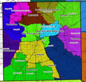
Start with Dallas County:

Interesting changes:
- White Rock and White Buffalo districts merged. (See detail below.)
- North Trail divided into 3 parts:
- Fair Park area (formerly part of Comanche), downtown, and West View District are combined with the Park Cities part of North Trail. (See detail below.)
- Richardson ISD portion.
- Dallas ISD north of Northwest Highway, including Dallas ISD portions that were part of North District.
- North becomes only Carrollton-Farmers Branch ISD.
- Gray Owl gets split up. (See detail below.)
- Unchanged:
- Wisdom Trail
- Mountain Lake
- Western Star
- Mustang
Here’s the merged White Rock/White Buffalo districts:

I always thought White Buffalo and White Rock should be combined. Both districts have more in common than other adjacent areas. Also, White Buffalo’s few traditional units didn’t make sense in a sea of program units.
Here’s Gray Owl:

It’s split into two parts:
- Garland ISD
- Rockwall County and Wylie and Communities ISDs. I think it also includes Royse City ISD, but Circle 10’s guidance wasn’t clear.
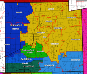
Here’s Collin County:

(Ignore the discontinuities on top left. I had GIS problems.) Notable changes:
- Great Plains (Plano ISD) divided into 2 districts along Parker Road.
- Southern Sky gets split. Southern Sky 1 is Allen ISD and Lovejoy ISD. Southern Sky 2 is Frisco, Celina, and Prosper ISDs.
- That’s Gray Owl 2 on the bottom right.
- I think Lone Star is the remainder of Collin County?
Here’s the old Texoma Valley Council, still its own district:

It includes Grayson County, TX and Bryan County, OK. I recently saw a Circle 10 billboard on southbound US 75 just north of the Red River.
Now let’s go southeast to Tawakoni:

This is Hunt and Rains Counties. Not sure this is even changed.
Cherokee gets split up. Part 1 has Kaufman and Van Zandt Counties:

I was in Pack 376 in Van, TX for a few years.
Here’s Cherokee Part 2 and Bluebonnet:

Bluebonnet is Ellis County, and Cherokee Part 2 is Navarro and Henderson Counties.
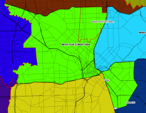
Let’s go back into Dallas and take a closer look at the southern part of North Trail:

Park Cities area, West View District, and Fair Park area are combined. I like that Scouts from the poorest parts of town will be able to share resources with the wealthiest part of the council.
I am glad Circle 10 is doing this. I hope everything goes smoothly and that each district’s volunteer leaders take this with a positive attitude. It’s for the better of Scouting in the east half of DFW.
Aren, thanks for doing this. I have distributed your blog to several Scouting buddies.
Aren,
Thanks for your mapping expertise and interest in Scouting. I am not sold on the benefits of breaking up the current Districts at the recommendations of some far of consultant working through local Scouters who were presented with a work group problem. This plan will put much pressure on the resources of volunteers and paid staff that will probably lead to diminished results from past years. There remain so many questions to be answered but I will try to be hopeful as we learn more.
Thanks,
Dick Dawson
Aren,
Wow. This is nice – it looks like it was a lot of work! I enjoy seeing all the different districts on the map – Circle 10 is a big place. I have to admit that it makes me grin a little to know that Texoma Valley District is the only district with an entire RIVER running through it! Love our Okie Scouters!
Thanks for doing this,
Connie
Aren, great job on the mapping! I began working on my Doctoral Project to realign Unit Commissioner Areas in North Trail a couple of months ago, which was temporarily put on hold with the prospect of these Council changes. At some point, I would like to discuss your best practices with the mapmaking tools you are using.
Thank you for your support to Scouting,
Dennis
I think you got it pretty much all correct.
-Ed Grune
Lone Star District DE
Would you happen to have this Council map as one graphic? I would think this would be a great thing to have for volunteers to know when we are camping in/out of Council.
I tried to see if I could make one map out of it, but unfortunately my tools aren’t good enough. I have SHPs for all this data, so anyone with suitable tools could do it.